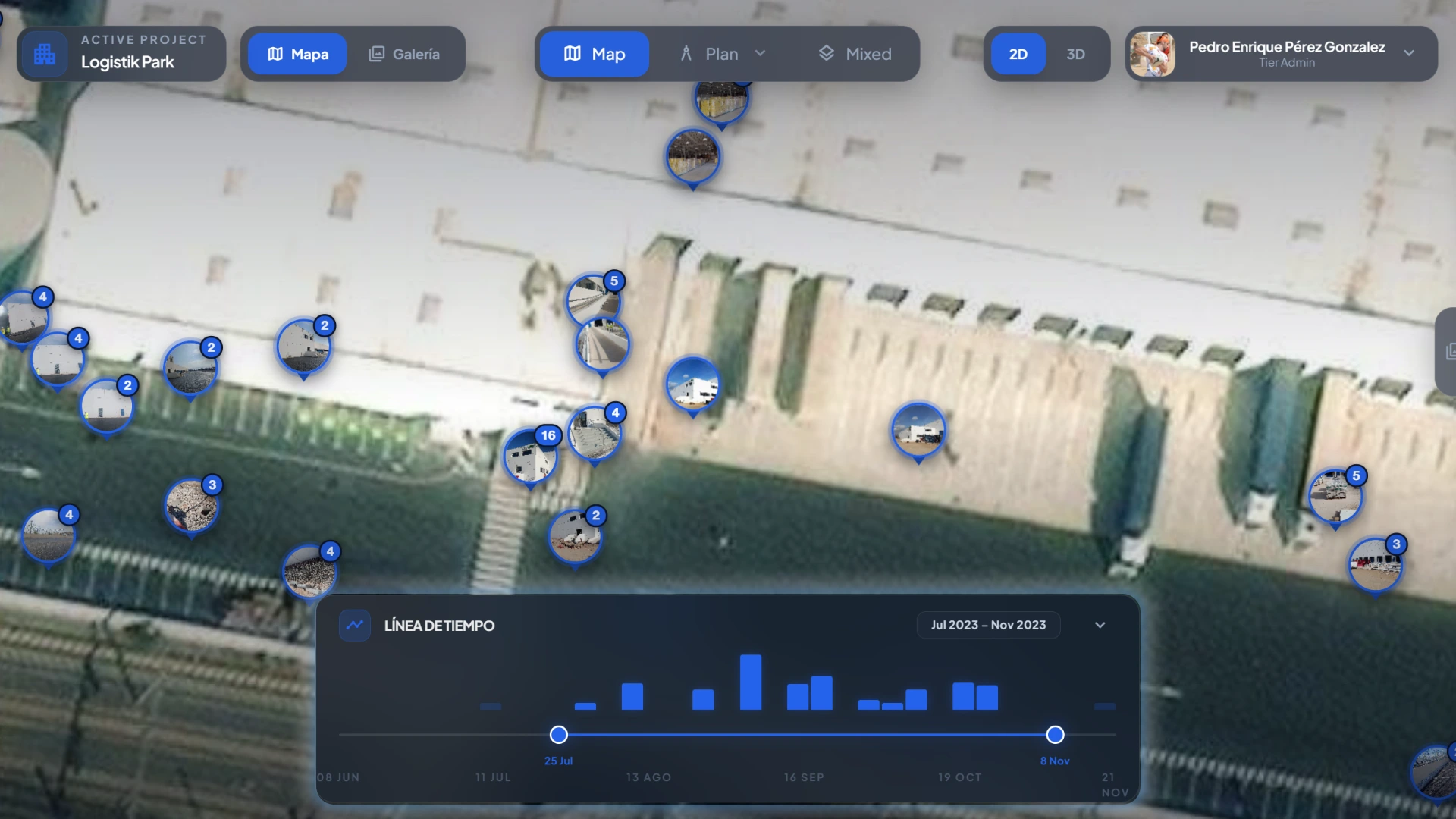
Construction photos
on drawings

Every construction photo, exactly where it belongs.

Pic on Site places your construction photos on drawings when GPS data is available, organizes them by date and author, and helps you find them with AI-powered visual search. No drones, no 360 cameras: just smartphone photos.

Map view with photo markers and a site visit timeline
Live site map

All photos placed directly on the project

Navigate on top of an orthophoto or drawing, open clusters, jump to the exact marker, and filter by dates with the timeline to understand how each area evolved.

Photo gallery filtered by a text search inside the app
Operational search

Find full batches with natural language

Type a term and the gallery returns the relevant images, including author, dates, and direct shortcuts to jump to the map or open the AI analysis.

Photo viewer with automatic description and AI-generated tags
Instant context

Every image comes with its technical reading

The viewer shows the full image, a structured description, and useful tags to classify installations, systems, and phases without extra manual work.

info What Pic on Site is

A SaaS platform for construction photo documentation

Pic on Site helps construction and BIM teams centralize smartphone photos, place them on maps or georeferenced drawings, and retrieve them later by date, author, area, or visual content.

It is designed for real site workflows: progress tracking, as-built support, shared photo repositories, payment applications, technical inspections, and visual reporting without drones or 360 cameras.

Smartphone photos Georeferenced drawings Visual search Visual traceability
error The problem

Construction photos exist, but nobody can find them

Each person on the team keeps site photos somewhere different: WhatsApp, email, computer folders, or their phone gallery. When you need them, there is no reliable way to retrieve the right image.

spatial_tracking

Photos scattered everywhere

WhatsApp threads, emails, personal folders, phone memory. Site photos are spread across dozens of disconnected places.

devices Spread across multiple devices
image_not_supported

A photo alone says very little

You see the image, but you do not know which area it belongs to, the exact date, or who took it. Without location and time context, the image loses documentary value.

help No reliable location or date context
image_search

Finding a photo means remembering when you took it

Thousands of images in one folder and your only fallback is guessing the approximate date. Without a smart search layer, finding the right photo is mostly luck.

search_off No efficient way to search
play_circle How it works

From photo to drawing in seconds

As simple as taking a photo.

No complex setup, no extra hardware.

Just your phone GPS.

auto_awesome Features

Everything you need to document your project

map

Automatic placement on drawings

Each photo is positioned automatically as an interactive marker on your georeferenced drawing. Open the image, metadata, date, author, and AI-generated tags from the same visual point.

Automatic GPS Interactive markers Smart clusters
search

AI-powered semantic search

Type "copper pipe" and find those exact photos. AI understands the visual content of each image.

timeline

Visit timeline

Navigate by site visit dates and compare visually how each area has advanced.

group

Team collaboration

Granular roles from owner to guest. Every photo records its author for full traceability.

label

Automatic AI tagging

Every photo receives AI-generated descriptions, tags, and categories automatically. No manual effort.

cases Use cases

One tool, multiple applications

Pic on Site adapts to the real needs of each project phase and team.

monitoring

Progress tracking

Document execution status with geolocated photos on the drawing. Verify work items, detect deviations, and keep visual evidence of progress without leaving the platform.

Daily follow-up Work-item verification
View use case arrow_forward
view_in_ar

As-built support

Locate hidden installations, construction details, and pre-close conditions. The timeline filter lets you see the exact state of any area on any date.

Timeline filter AI search
View use case arrow_forward
cloud_sync

Shared photo repository

One single source of truth for the whole team. No more photos scattered between WhatsApp, Google Drive, and phone galleries. Everything centralized with author, date, and location.

Traceability Collaboration
View use case arrow_forward
receipt_long

Payment applications and completed work review

Support work execution with geolocated, date-stamped visual evidence. Export filtered photos by area and time period to attach them to payment reviews.

Date-stamped evidence Bulk export
View use case arrow_forward
troubleshoot

Inspections, defects, and pathologies

Document defects, cracks, and damage with precise placement on the drawing. Ideal for technical reports, claims, and repair follow-up.

Precise location Visual history
View use case arrow_forward
present_to_all

Client progress updates

Share project progress visually without requiring in-person site visits. Map and drawing views with markers make progress easy to communicate.

3D view Remote follow-up
people Who it's for

Designed for construction professionals

Every role in the project team has a practical reason to use Pic on Site.

view_in_ar

BIM modelers

Find construction detail photos quickly when updating the as-built model.

manage_accounts

BIM managers

Review photo traceability and confirm that site documentation stays aligned with the model.

sync_alt

BIM coordinators

Verify execution status from the office using geolocated visual records.

engineering

Site managers

Capture and place photos without manual processes. Document progress directly from the field.

architecture

Architects

Review site evolution visually and validate execution against the design intent.

construction

Contractors

Capture execution evidence and report issues with exact location directly on the drawing.

verified Trust

Ready for construction teams

cloud_done

Web infrastructure

Browser-based access

shield

Secure access

User controls

smart_toy

Visual AI

Search by content

speed

Team workflows

Centralized photos

quiz FAQ

Frequently asked questions

Direct answers to understand where Pic on Site fits and what it needs to work well on real projects.

What is Pic on Site?

Pic on Site is a SaaS platform for construction photo documentation. It centralizes smartphone photos, places them on maps or georeferenced drawings, and lets teams retrieve them later by date, author, location, or visual content.

Do I need drones, 360 cameras, or special hardware?

No. Pic on Site is built for teams that already work with photos captured on a regular smartphone.

How are photos placed on the drawing?

When the image contains valid GPS metadata, Pic on Site can place it automatically on the project map or georeferenced drawing.

Can I search photos by what appears in the image?

Yes. Pic on Site includes AI-powered visual search so teams can find relevant photos without depending only on folders, filenames, or approximate dates.

We are validating the product and
looking for collaborators

Pic on Site is in validation stage. We are looking for construction professionals who want to help us refine the proposal, test the tool, and give real field feedback.